the Creative Commons Attribution 4.0 License.
the Creative Commons Attribution 4.0 License.
 | 12 Aug 2025
WaDA – water diplomacy automation: using blockchain, AI, and environment IoT for water management and climate action
Jeet Biswas
Markus Haid
Ashutosh Bhalerao
Stephan Engelhardt
Sebastian Lemke
Poor water management has led to conflicts worldwide and significant loss of life and property. According to the UN, by 2040, nearly one in four children will live in an area with limited water resources. Poor water management has also been a critical factor in accelerating climate change. Climate change, in turn, intensifies extreme weather events, leading to more frequent and severe floods. The traditional water level monitoring stations are outdated, invasive, and limited in telemetry capabilities, resulting in numerous fatalities due to the lack of an effective early warning system. WAMO 300 (Water Monitor 300) introduces an innovative and noninvasive method of measuring water levels using navigation satellites such as GPS or Galileo, providing real-time alerts to various stakeholders. This study evaluates the feasibility of the WAMO 300 system and proposes decentralised water management solutions, leveraging this system to promote sustainable water diplomacy.
- Article
(1696 KB) - Full-text XML
- BibTeX
- EndNote


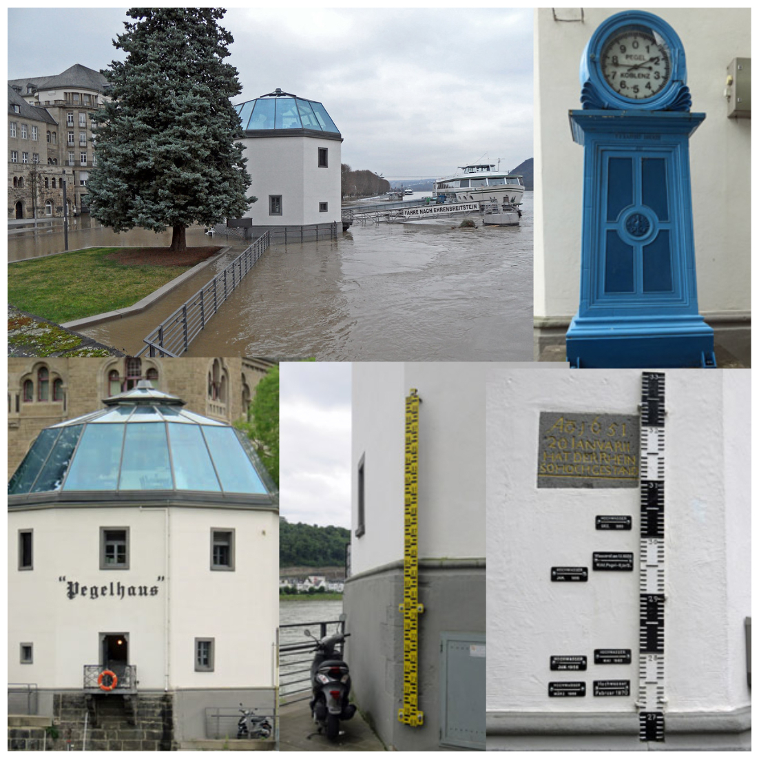
Rivers have played a crucial role in the development of civilisations, enabling human progress through engineering and agricultural expansion. However, the overutilisation of water resources and the release of harmful chemicals have led to the destruction of rivers and sparked conflicts over water sharing (Yemi Lufadeju, 2017). For example, the Nile River is a source of contention among nine African countries (Swain, 2011), while the Brahmaputra River, one of the largest rivers in the world in terms of both length and discharge, regularly causes flooding and conflict in Bangladesh, India, and China (Malhotra, 2010; Giordano and Wahal, 2022; Khadka, 2017; Pradhanang et al., 2017). The Rhine River system in Europe is crucial for industry but faces increasing challenges, including droughts and floods, exacerbated by overexploitation and climate change (Huang et al., 2015). In July 2021, an extreme flood occurred in the Rhine Basin, with up to 180 presumed deaths and infrastructure damage in the billions. The losses occurred due to a lack of measures, situational knowledge, and equipment in civil protection (Thieken et al., 2023). In the digital age, water diplomacy still remains a significant concern. Often, there is no existing infrastructure to generate data, or the available technology is either costly, outdated, or both. Globally, countries use stream gauges or gauging stations to measure the river water level, as shown in Fig. 1. Such installations require physical structures to be installed directly in the water body, which disrupts aquatic ecosystems and potentially alters water flow, sedimentation patterns, and habitats of aquatic organisms. They are immobile, making it challenging to adapt them to changing monitoring needs, and often lack telemetry, making remote operation or data logging impossible, thus increasing maintenance costs (Joo et al., 2021). Additionally, the bodies responsible for hydrological data are sometimes reluctant to share data, citing reasons such as technical failure, and sometimes, the data are heavily manipulated, making reliability a colossal challenge (India PT, 2018).
The WAMO 300 system, short for Water Monitor 300, is a low-cost, community-driven, real-time surface water assessment platform. WAMO 300 is noninvasive as it operates as a floating platform. Its satellite-based water level measurement reduces ecological disturbance and maintenance requirements. Additionally, WAMO is mobile and modular and can be deployed in different locations as needed, making it a more flexible and sustainable solution. With an ensemble of sensors, the device is capable of providing real-time monitoring and timely alerts. A combination of the WAMO 300 hardware and the software platform can help various stakeholders, such as water authorities, firefighters, and local people, take timely action and reduce losses in times of emergency.
The technology proposed in this paper is a combination of already existing technologies. In this section, brief descriptions of these technologies have been provided, which are crucial for a better understanding of the overall system.
2.1 Internet of Things (IoT) for environmental monitoring
WAMO 300 exemplifies an IoT solution for environmental monitoring. The Internet of Things (IoT) refers to a network of interconnected devices capable of collecting and exchanging data. Each device, or “thing”, is any physical object in the world that has been provided with a unique identity (Madakam et al., 2015). These devices are embedded with sensors, software, and other technologies that enable them to communicate with other devices and systems over the internet. WAMO is equipped with various sensors to measure key water parameters and transmit these data to a database. This real-time data collection and transmission capability allows for continuous monitoring of water bodies, providing critical information for stakeholders to manage water resources effectively and respond to environmental changes swiftly.
2.2 Water level measurement using the Satellite Navigation System and real-time kinematics
WAMO 300 employs the satellite navigation system to determine the water level. Satellite navigation systems use satellites from a particular constellation to determine the position. These systems can be classified as either a GNSS (Global Navigation Satellite System) or RNSS (Regional Navigation Satellite Service) based on the coverage of the constellation. In addition to latitude and longitude, the position information includes altitude (height from average mean sea level) and time. WAMO 300 uses this message to determine the level of the water body. Satellite navigation systems have a horizontal accuracy of around 10 m and a vertical accuracy of around 30 m because of atmospheric factors such as ionospheric delay and multipath. To mitigate this, systems such as the WAAS (Wide Area Augmentation System), GBAS (Ground-Based Augmentation System), EGNOS (European Geostationary Navigation Overlay Service), and D-GNSS (differential GNSS) are used (Prasad and Ruggieri, 2005). Such correction techniques improve the accuracy to centimetre level.
WAMO 300 uses RTK (real-time kinematics), which is a type of D-GNSS. D-GNSS employs a reference station to broadcast error corrections, which is used by rovers to improve the calculations. The accuracy of measurement depends on the signal processing capability of receiver electronics (Grewal et al., 2020). RTK uses the satellite signal's carrier wave as its signal, ignoring the information contained within, simplifying the signal processing and reducing the cost of receivers (Langley, 1998). The base station re-broadcasts the phase of the carrier it observes, and the mobile units compare their phase measurements with the received phase from the base station. The range of a satellite is essentially calculated by multiplying the carrier wavelength times the number of whole cycles between the satellite and the rover and adding the phase difference. This technique enables low-cost RTK devices to achieve centimetre-level positioning accuracy. Hence, using RTK, the WAMO 300 system is able to reduce hardware costs and reach a vertical accuracy of 10 cm.
2.3 Web3 and blockchain for trust among stakeholders
Web3 represents the third generation of internet usage, aiming to decentralise and empower users. The first generation of the web, or Web1, was decentralised but lacked usability. Web2 led to the centralisation of control in the hands of a few tech giants. Web3 seeks to distribute control back to users through decentralised, peer-to-peer, and self-sovereign, scalable technologies (Yeoman and Sutton, 2022). Water management involves the participation of diverse stakeholders. A decentralised solution offers advantages, including increased resilience, local adaptability, and transparency.
Blockchain powers Web3, and Ethereum introduced smart contracts (Mattila, 2016). Smart contracts constitute a programme or set of instructions that are executed when certain conditions are made (Dannen, 2017). These are self-executing digital contracts with the terms of the agreement between various stakeholders directly written into code, making them the foundation of IoT in Web3. WAMO produces data that are of public interest. Water level data are made publicly available by websites such as Hochwasser RLP (https://www.hochwasser.rlp.de/, last access: 14 July 2025) maintained by the German state of Rhineland-Palatinate and Pegelonline (https://www.pegelonline.wsv.de/, last access: 14 July 2025) maintained by the Federal Ministry of Transport and Digital Infrastructure. By leveraging blockchain, the WAMO 300 system can ensure that the environmental data collected and transmitted by its sensors are tamper-proof and verifiable, fostering trust among all parties involved in water management. In addition to adding a layer of trust, it could also decrease maintenance costs.
2.4 Oracles for connecting the physical world with Web3
In the context of Web3, oracles play a crucial role in bridging the gap between blockchain smart contracts and real-world data. Smart contracts operate as self-executing contracts, with the terms of the agreement directly written into code on the blockchain. However, they cannot directly access external data or interact with the outside world. An oracle is a mechanism by which smart contracts interact with anything that is outside the blockchain (Beniiche, 2020). Oracles serve as intermediaries that fetch, verify, and transmit external data to smart contracts, enabling them to execute based on real-world information. In the context of this paper, the WAMO 300 functions as a blockchain oracle, providing real-time environmental data – such as water levels, temperature, biochemical oxygen demand (BOD), turbidity, pH, and total organic carbon (TOC) – to the blockchain. This ensures that smart contracts have accurate and reliable information for decision-making processes.
2.5 Artificial intelligence in Web3
Artificial intelligence (AI) involves the simulation of human intelligence processes by machines, particularly computer systems. These processes include learning, reasoning, and self-correction. In the context of Web3, AI can enhance the functionality and efficiency of decentralised systems.
Traditional centralised AI systems often face challenges such as high computational resource demands, data privacy concerns, and scalability issues. Decentralised AI (DAI) addresses these problems by distributing AI tasks across multiple nodes or devices within a network (Vincent et al., 2023). Each node operates independently, processing data locally and communicating with other nodes to share insights and learn collectively. This decentralised approach reduces latency, improves data privacy, and enhances system resilience. A network of WAMO 300 devices can provide edge computing benefits from proximity to data. In the network, AI algorithms can analyse the collected environmental data to detect patterns, predict trends, and provide actionable insights. This collaborative learning model enables faster and more adaptive responses to environmental changes, supporting sustainable water management practices.
2.6 Workflow
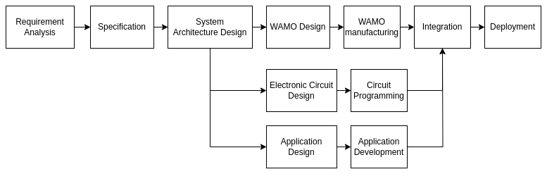
This paper introduces the first version of the in situ water monitor known as WAMO. The development involved extensive consultations with various stakeholders to tailor the device to their specific needs. Key public sector stakeholders included the Municipality of Lübeck, which emphasised the necessity for improved storm surge preparedness and environmental monitoring. The Darmstadt Green Spaces Office focused on optimising water quality and ecological research, while Mecklenburg-Vorpommern stressed the importance of sensor technology for comprehensive water quality monitoring across multiple lakes. Additionally, insights from Darmstadt's Smart City initiative contributed to real-time water level monitoring and automated flood management. Communication with these stakeholders was conducted through workshops, interviews, and surveys, allowing for a thorough understanding of their requirements. This engagement led to the development of WAMO, designed to address the diverse needs identified in these interactions, such as real-time monitoring and environmental impact assessment. Based on the stakeholders' needs, a specification list was created, which detailed the materials for WAMO and the selection of sensors, microprocessors, telemetry options, and cloud platforms. Once these specifications were frozen, a comprehensive system architecture was developed, encompassing both the application and the electronics. The development process was then divided into three domains: the electronics component, the cloud application for data visualisation, and the in situ platform itself. After the individual components were developed, they were integrated, and the system was deployed for testing.
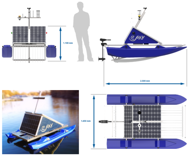
3.1 WAMO 300 system
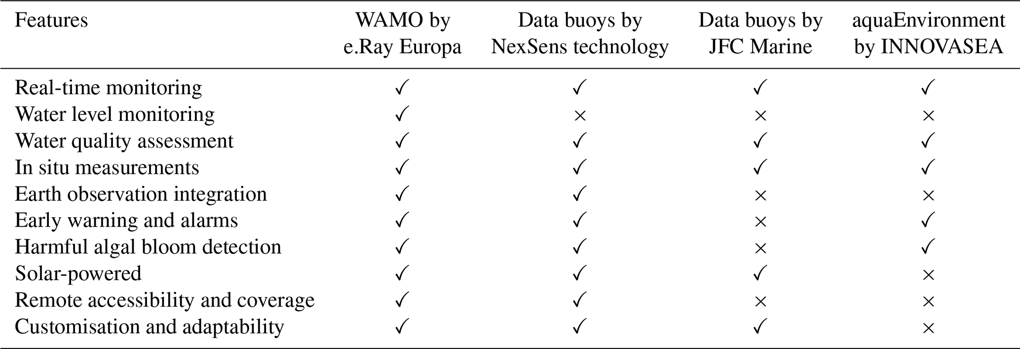
WAMO 300 is a self-sustainable, movable floating platform developed through a community-driven, modular strategy that allows for customisation of the onboard sensor array according to the needs of the utilising community. The “300” signifies the incorporation of three solar panels, providing a peak capacity of 300 W. Equipped with a GNSS receiver, it facilitates precise water level measurements and supports the integration of additional sensors for comprehensive water quality assessment. As shown in Table 1, this system distinguishes itself from existing commercial water monitoring solutions by offering an integrated suite of features, including real-time monitoring, water level evaluation, and early detection of flood conditions and harmful algal blooms, providing critical alerts often absent in competing systems. Its solar-powered architecture ensures sustained operation independent of external power sources, while its design promotes remote accessibility and adaptability, enabling targeted solutions tailored to specific environmental monitoring needs.
The primary objective is to achieve precise measurements of water levels, as conventional in situ sensor systems typically utilise pressure sensors that necessitate regular calibration. The innovative aspect of this solution lies in the application of the U-Blox C94-M8P RTK-based sensor for water level monitoring. The height from the average mean sea level is considered the water level. Upon receiving a correction message from a base station, the rover transitions to RTK float mode. In this mode, the accuracy of the measurements can vary from metre level to decimetre level, depending on several influencing factors. These factors include the number of satellites being tracked, the geometry of the satellite receiver, the utilisation of pseudo-range data alongside carrier phase measurements, the degree of observation noise, and the application of dual-frequency observations (Langley, 1998). When accuracy improves to below 10 cm, the rover enters RTK fixed mode, which represents the optimal operational state for this monitoring application.
The power management system of the WAMO comprises three 100–120 W solar PVs for power generation and a 60 Ah battery for up to 3 d of backup, making it an autonomous power system. This system incorporates an energy management unit that operates within a voltage range of 3.8–24 V DC, adhering to marine safety standards. A Raspberry Pi microprocessor serves as the central processing unit, overseeing data acquisition, processing, storage, and transmission while also monitoring the integrated battery management system (BMS) for safety.
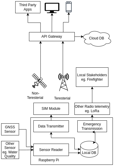
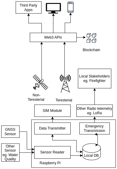
Sensors within the system are polled every 60 s. When parameters breach predefined thresholds, the microprocessor leverages LoRaWAN technology to transmit warnings to local stakeholders. Acquired data are stored in a local SQL database and sent to a central cloud server via secure HTTPS requests for downstream applications. As shown in Figs. 4 and 5, the telemetry system supports diverse communication methods, including GSM, LTE, LoRa, Wi-Fi, and non-terrestrial modes, allowing configurable polling and transmission frequencies based on service level agreements.
Data can be exported in standard formats such as JSON or XML, with alarm strategies including push notifications, email, or SMS alerts implemented through cloud data. Additionally, the system supports the integration of extra sensors, notably multispectral sensors, which monitor critical water parameters like temperature, dissolved oxygen, turbidity, and TOC. These measurements are vital for detecting harmful algal blooms and biodiversity loss. The innovative design enables rapid integration, flexible installation, and straightforward maintenance for effective environmental monitoring.
Table 2Various parameters that WAMO can measure.
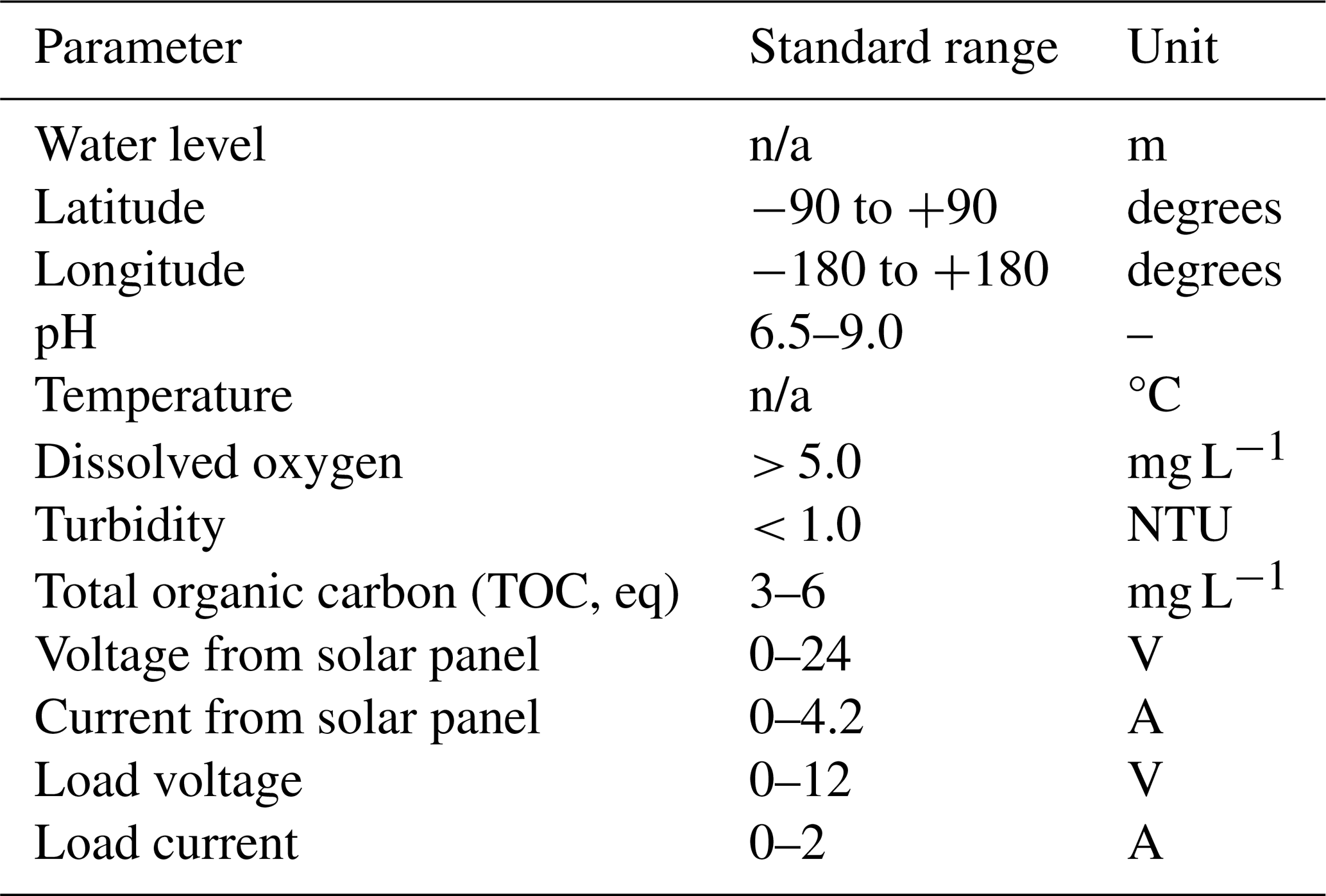
n/a: not applicable.
The primary objective of WAMO is to comprehensively understand surface water systems through precise and quantifiable data, which are essential for effective resource management. A network of WAMOs strategically placed along rivers can serve dual purposes:
-
River data collection
-
Timely emergency warnings
The extreme flood in Germany in 2021 shows that measurement alone is not enough. In case of emergency, timely distribution of information to the concerned stakeholders can reduce the damage drastically. This network of WAMOs can provide valuable insights into river conditions, facilitating efficient water management through the regulation of dams, canals, and catchment areas. In the event of water scarcity downstream, upstream gates can be opened to ensure water flow. Conversely, if a flood occurs upstream, WAMO data can guide the redirection of water flow to canals or catchment areas. Furthermore, real-time monitoring of water chemical composition can allow swift responses to chemical leaks and eutrophication threats.
3.2 Decentralised approach to data handling
The River Sense application has been designed as a web-based platform for visualising sensor data, currently utilising Google Firebase DB for cloud data storage. However, centralised databases are inherently susceptible to risks of data manipulation and single points of failure in the case of a cyber-attack. To mitigate these risks, a decentralised data management approach leveraging blockchain technology is proposed. Figures 4 and 5 illustrate the data flow management of centralised and decentralised systems. In a centralised system, the data are sent from WAMO to the database hosted in the cloud. In a decentralised ecosystem, WAMOs function as oracles, collecting real-world data to be recorded on the blockchain. This ensures the immutability and transparency of information. To enhance the integration and utilisation of this data, Application Programming Interfaces (APIs) can be developed to enable third parties to create decentralised applications (dApps) and explore innovative use cases. This decentralised approach provides a method for overcoming the limitations inherent in centralised systems, notably improving data integrity and fostering collaborative potential.
Long-term data gathered by WAMOs can play a crucial role in developing predictive models that elucidate seasonal water level patterns. These data are vital for training models aimed at forecasting floods and droughts, thereby enhancing water resource management and supporting informed decision-making (Mosavi et al., 2018). A synergistic combination of historical data and real-time variables – such as water levels, precipitation, flood frequency analysis, and daily flows – alongside machine learning (ML) algorithms such as artificial neural networks (ANNs), neuro-fuzzy systems, adaptive neuro-fuzzy inference systems (ANFISs), support vector machines (SVMs), wavelet neural networks (WNNs), and multilayer perceptrons (MLPs) facilitates both short-term and long-term flood prediction. Neural networks are particularly noted for their superior accuracy, fault tolerance, and powerful parallel processing capabilities, making them well-suited for complex flood prediction tasks, even with incomplete datasets. The ongoing development of hybrid and ensemble machine learning methods aims to enhance further the accuracy, performance, and robustness of these predictive models.
The extensive data generated by a network of WAMOs necessitate substantial computational resources for developing accurate models. To address these challenges and improve the quality of predictions in terms of accuracy, generalisation, uncertainty, lead time, speed, and computational costs, federated learning (Vincent et al., 2023) approaches can be employed.
Federated learning, which combines artificial intelligence, blockchain, and edge computing, allows for the training of large models without the need for centralised data collection. A network of decentralised agents, in this case WAMOs, operates as collaborative participants in the remote exchange of data, enhancing it recursively akin to a brainstorming team. Each participant trains an individual model using their unique dataset and subsequently encoding the model's new configuration. The updated model data are averaged and incorporated into the collective deep learning model. This cooperative training process can persist until the model attains full convergence. Such an approach not only preserves data privacy and security but also leverages decentralised resources for model development, thereby offering a scalable and efficient solution for environmental data analysis and predictive modelling.
4.1 Experiment setup and goal
The experiment was conducted in Woog Lake in Darmstadt in collaboration with the Darmstadt city authority. The primary goal of the experiment was to demonstrate the system's capability in a near-real-life scenario, while also demonstrating its reliability over an extended duration. The observations recorded during this period would be valuable in improving the functionality of the system in subsequent iterations.
4.2 Observation
The total number of days was 79 and the total number of readings was 107 929.
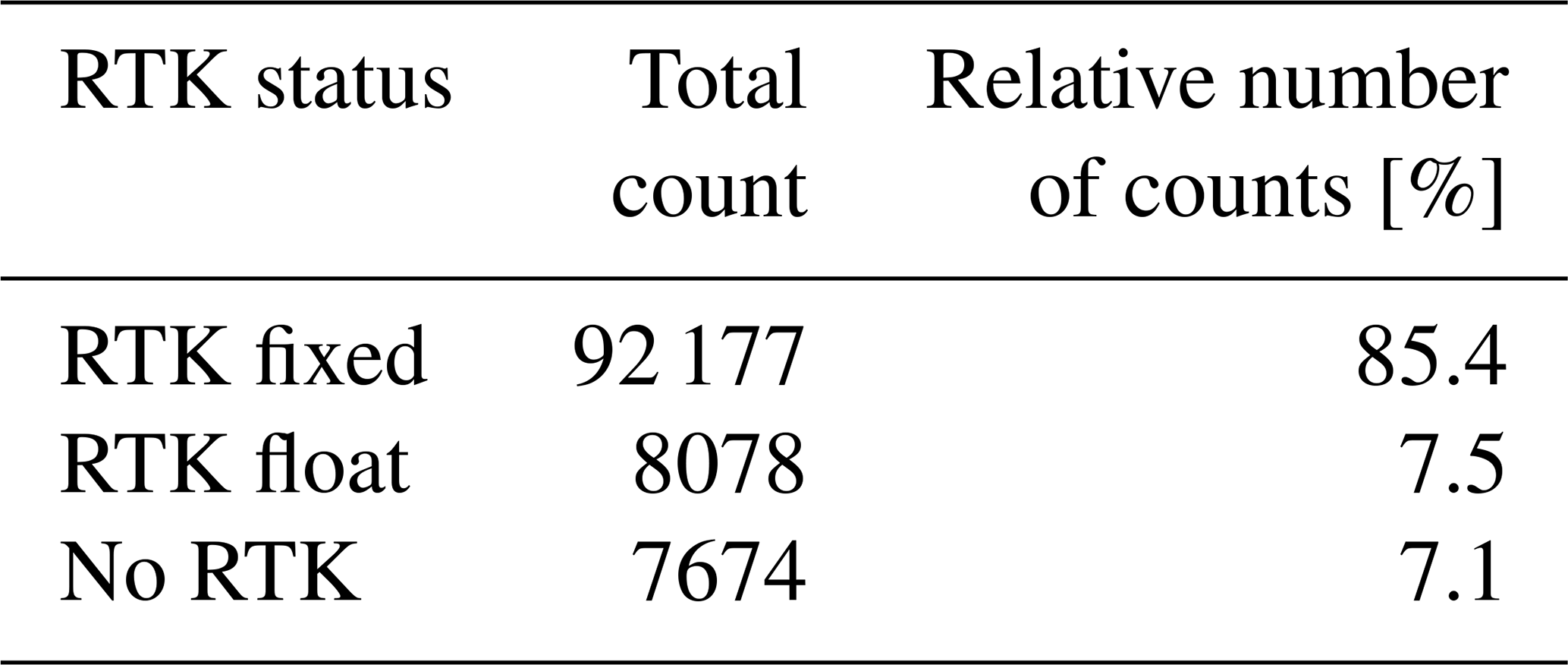
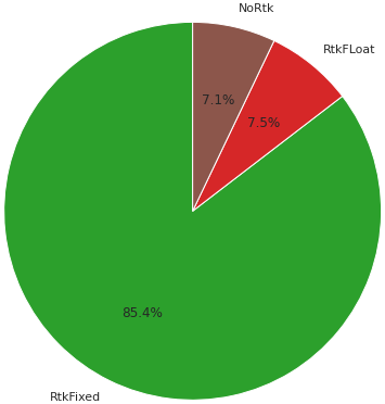
As shown in Table 3 and Fig. 6, the system operated in RTK fixed mode for 85.4 % of the time. Further, the availability of RTK float mode increased the overall uptime to 92.9 %. The instances of no RTK mode were because of electrical faults in the reference base station. Such issues can be mitigated by proper electrical installation, thereby increasing the system's availability further. Utilising a suitable N-TRIP data provider, such as the SA-POS service provided in Germany, can remove the dependence on a personal base station. The satellite positioning service SA-POS is a joint initiative of the Association of Surveying Administrations of the Federal Republic of Germany (AdV). The basis of the SA-POS service is a network of around 270 GNSS reference stations permanently operated in the federal states and other reference stations in the neighbouring states. The extensive network ensures the provision of highly accurate and uniform correction data services in the official three-dimensional reference system for the entire country. Additional information can be accessed on their website: https://sapos.de/, last access: 14 July 2025.
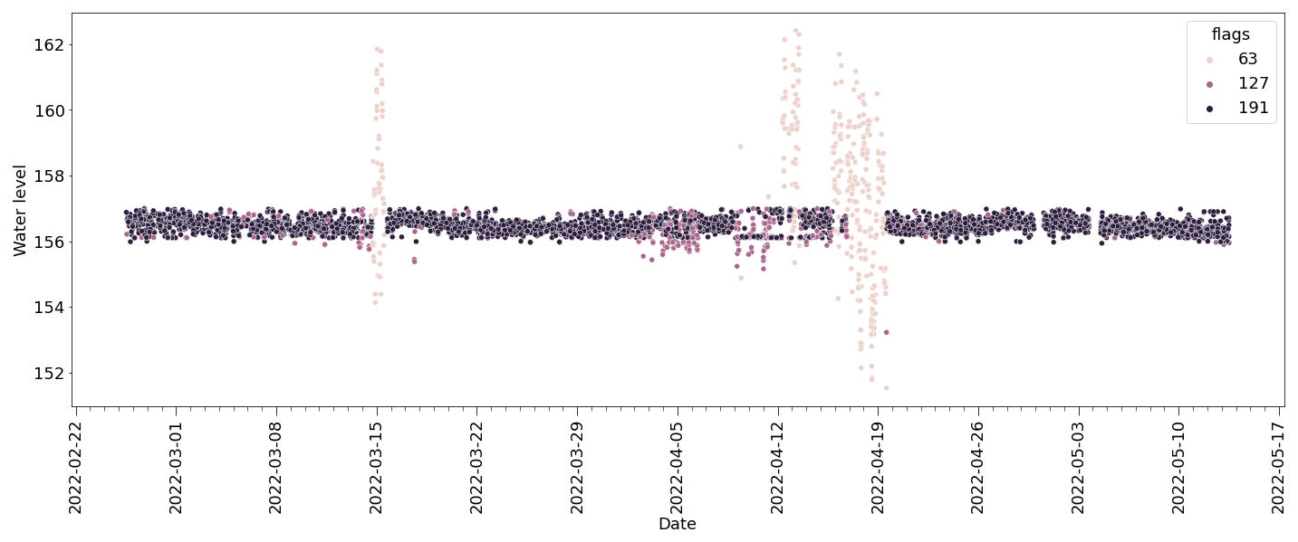
In order to evaluate the performance in various RTK modes, 5000 random samples were analysed. Figure 7 illustrates the time series of the values, highlighting three operational modes, as noted in Sect. 3.1. Flag 63 refers to the unavailability of RTK correction messages, flag 127 corresponds to RTK float mode, and flag 191 refers to RTK fixed mode. As can be seen in the figure, when the RTK correction messages are not available, the precision is significantly diminished. In RTK float mode, the readings have higher precision; however, the readings are most precise when they are in RTK fixed mode. Achieving RTK fixed mode requires satisfying multiple conditions; therefore, RTK float mode data could be enhanced through AI-driven post-processing techniques to yield more insightful results. Additionally, the implementation of dual-band satellite receivers is recommended, as they can provide superior accuracy over those utilising only single-band systems.
5.1 Governments
The primary benefits of the WAMO system are to government bodies. The real-time data collected by such a system can be utilised to gain valuable insights into environmental conditions and improve decision-making processes. Such data facilitate optimised resource management, including water and energy usage, and support the development of evidence-based policies. Such advancements, in turn, aid in biodiversity conservation and climate change adaptation while facilitating diplomatic engagements among national and federal entities. Additionally, compliance with the EU Data Act mandates the public accessibility of non-personal data, particularly in emergency contexts. The incorporation of blockchain technology enhances the system by reducing maintenance and security costs, thereby ensuring more efficient and transparent governance.
5.2 Local bodies
The WAMO system offers substantial benefits to local communities through its emergency alert capabilities, which deliver real-time warnings and enhance public safety. The integration of multi-outlet telemetry, particularly LoRaWAN, enables efficient data transmission within communities. This system not only provides actionable insights but also empowers residents to participate actively in environmental sustainability initiatives. Consequently, it fosters a sense of responsibility and significantly enhances the overall quality of life for community members.
5.3 Researchers
WAMO acts as an in situ sensor. In situ data and remote sensing data are complementary sources of information that, when used together, provide a more comprehensive and accurate understanding of environmental conditions and processes. While new remote sensing technologies are able to detect water data in high quality and large quantities, operational applications are still limited by deficiencies of in situ verification. Remote sensing delivers the overall picture, and in situ measuring provides localised, high-resolution measurements over a wide range of parameters (Sputh et al., 2008). This can play a pivotal role in advancing scientific knowledge and supporting practical applications across a wide range of scientific disciplines.
5.4 Insurance sector
The integration of environmental IoT technology within the insurance industry significantly enhances risk assessment, customer service, and loss reduction. The WAMO system delivers real-time, precise environmental data, enabling insurers to evaluate risks better and provide more cost-effective coverage. This capability is essential for developing robust risk-transfer mechanisms in regions susceptible to climate-related disasters. Moreover, blockchain technology reduces administrative overhead and ensures accurate claims processing (Ahmad and Saxena, 2022). Collectively, these innovations improve the efficiency, transparency, and responsiveness of the insurance sector, ultimately benefiting both insurers and policyholders.
The water resource remains the most critical resource for survival. The management of water has always been a big challenge. Water diplomacy still remains a reason for conflict in various parts of the globe. With the innovative WAMO 300 system, a decentralised solution for this problem has been suggested. The primary goal of the experiment was to test the feasibility of such a system. The experiment was conducted in Woog, which is a swimming lake in Darmstadt. Although snow and heavy rainfall were encountered, they do not resemble the extreme cases that the solution is trying to address. The device is planned to be tested in a different environment, such as a river. The Rhine Commission has shown interest. This will help understand the technical challenges of deploying such a system in rivers. In addition to that, a network of WAMOs will demand huge investment, and hence, a proper cost estimation of such a network needs to be done.
High-precision RTK positioning solutions are essential for accurate water level measurements. The use of dual-band GNSS chips such as C099-F9P may further increase the accuracy of measurements in RTK float mode or even when there is no RTK message. In addition, a sensor with dual-band support goes from RTK float mode to RTK fixed mode faster than a sensor that supports only a single band.
The next step involves reducing the dependency on centralised systems by adopting decentralised solutions. Algorithms shall be developed to predict floods based on real-time data provided by WAMO. The paper by Amir Mosavi, Pinar Ozturk, and Kwok-wing Chau (Mosavi et al., 2018) on flood prediction using machine learning will be the foundation of the AI part of the project. In addition to the water level, the flexibility of the system to accommodate additional sensors further increases the system's potential. WAMO's measurements can be used to establish models for understanding potential changes in water quality and monitoring surface water conditions. With this system, the changes caused by various factors can be observed, and hence, better strategies for climate adaptation can be developed. The integration of Earth observation data with the application will further improve the platform's data analytics capability. The WAMO system, with its emergency services for rural populations, helps take a step towards a sustainable future.
The codes for the experiment are owned by eRay Europa GmbH and are not publicly available. However, upon special request, they can be made available to interested parties.
The experimental data are owned by eRay Europa GmbH and are not publicly available. However, upon special request, they can be made available to interested parties.
JB was responsible for the conceptualisation and design of the overall system, drafting the initial paper, and coordinating the research activities. He also played a lead role in developing the system architecture, designing the experimental framework, and implementing key components of the software platform. In addition, he coordinated communication with external stakeholders and integrated feedback into the system design.
AB contributed significantly to the methodology design and system validation by supplying technical specifications and study materials essential for development and experimentation. His expertise supported the selection of sensors and contributed to the design of the telemetry architecture.
SE co-developed the hardware and software infrastructure alongside JB. He was instrumental in the integration of electronic components, field deployment, and troubleshooting of the WAMO 300 system. He also supported the adaptation of the system to various use-case scenarios and ensured compliance with marine and safety standards.
SL led the funding acquisition and resource mobilisation efforts that made the experimental deployment possible. He managed collaborations with partner institutions, ensured access to test sites, and facilitated the logistical support required for the successful execution of the study.
MH supervised the research project, offering continuous academic guidance and oversight throughout its life cycle. His contributions included strategic feedback during the planning, development, and evaluation phases, ensuring scientific rigour and alignment with broader research objectives.
All authors participated in the critical review and editing of the paper and approved the final version for submission.
The contact author has declared that none of the authors has any competing interests.
Publisher’s note: Copernicus Publications remains neutral with regard to jurisdictional claims made in the text, published maps, institutional affiliations, or any other geographical representation in this paper. While Copernicus Publications makes every effort to include appropriate place names, the final responsibility lies with the authors.
This article is part of the special issue “Sensors and Measurement Science International SMSI 2023”. It is a result of the 2023 Sensor and Measurement Science International (SMSI) Conference, Nuremberg, Germany, 8–11 May 2023.
Firstly, we would like to thank the Department of Electrical Engineering and Information Technology at Hochschule Darmstadt, the Bundesministeriums für Wirtschaft und Energie, the European Space Agency, HEAG, and the city of Darmstadt for giving us the necessary resources and funding to carry out the research. Secondly, as English is not our first language, we have used artificial intelligence, namely Grammarly Pro and ChatGPT 3.5, for proper phrasing and grammatical editing on an earlier version of the paper. We are thankful to the engineers who made these technologies available to the world. Lastly, we acknowledge that scientific work is the accumulation of generational knowledge. So, we thank all the scientists, engineers, and thinkers who worked before us and built the knowledge-sharing community from which we could benefit. By remembering their contribution, we hope to deliver an equitable society for the next generation.
The water measuring equipment, WAMO, was developed under the European Space Agency's business incubation programme. HEAG and the city of Darmstadt provided logistical support for the experiment.
This paper was edited by Qingquan Sun and reviewed by two anonymous referees.
Ahmad, S. and Saxena, C.: Internet of Things and Blockchain Technologies in the Insurance Sector, 2022 3rd International Conference on Computing, Analytics and Networks (ICAN), Rajpura, Punjab, India, 1–6, https://doi.org/10.1109/ICAN56228.2022.10007267, 2022.
Beniiche, A.: A Study of Blockchain Oracles, arXiv [preprint], https://doi.org/10.48550/arXiv.2004.07140, 2020.
Dannen, C.: Introducing Ethereum and solidity, Vol. 1, Berkeley: Apress, https://doi.org/10.1007/978-1-4842-2535-6, 2017.
Giordano, M. and Wahal, A.: The Water Wars Myth: India, China and the Brahmaputra. What the hydrology and geopolitics of the Brahmaputra River mean for India-China water relations, United States Institute of Peace, https://www.usip.org/publications/2022/12/water-wars-myth-india-china-and-brahmaputra last access: 8 December 2022.
Grewal, M. S., Andrews, A. P., and Bartone, C. G.: Differential GNSS, Global Navigation Satellite Systems, Inertial Navigation, and Integration Wiley, 293–330, https://doi.org/10.1002/9781119547860.ch8, 2020.
Huang, S., Krysanova, V., and Hattermann, F.: Projections of climate change impacts on floods and droughts in Germany using an ensemble of climate change scenarios, Reg. Environ. Change, 15, 461–473, https://doi.org/10.1007/s10113-014-0606-z, 2015.
India PT: Can't share hydrological data of Brahmaputra river with India for now: China, Economic Times, https://economictimes.indiatimes.com/news/defence/cant-share-hydrological-data-of-brahmaputra-river-with-india-for-now-china/articleshow/60478124.cms?from=mdr (last access: 14 July 2025), 13 July 2018.
Joo, H., Lee, M., and Kim, J.: Stream gauge network grouping analysis using community detection, Stoch. Env. Res. Risk. A, 35, 781–795, https://doi.org/10.1007/s00477-020-01916-8, 2021.
Khadka, N. S.: The China-India row that spells disaster for flood victims, BBC World Services, https://www.bbc.com/news/world-asia-india-42335242 (last access: 14 July 2025), 2017.
Langley, R. B.: Rtk gps, Gps World 9.98, 70–76, https://gge.ext.unb.ca/Resources/gpsworld.september98.pdf (last access: 14 July 2025), 1998.
Madakam, S., Ramaswamy, R., and Tripathi, S.: Internet of Things (IoT): A Literature Review, J. Comput. Comm., 3, 164–173, https://doi.org/10.4236/jcc.2015.35021, 2015.
Malhotra, P.: Water Issues between Nepal, India, and Bangladesh, IPCS Special Report, https://www.files.ethz.ch/isn/118874/SR95.pdf (last access: 14 July 2025), 2010.
Mattila, J.: The blockchain phenomenon-The Disruptive Potential of Distributed Consensus Architectures, BRIE Working Paper 2016-1, https://www.researchgate.net/publication/313477689_The_Blockchain_Phenomenon_-_The_Disruptive_Potential_of_Distributed_Consensus_Architectures (last access: 14 July 2025), 2016.
Mosavi, A., Pinar, O., and Chau, K.: Flood prediction using machine learning models: Literature review, Water, 10, 1536, https://doi.org/10.3390/w10111536, 2018.
Pradhanang, S., Khadka, U. R., and Thakuri, S.: Fresh Water Resources of Nepal: Perspectives and Issues, ResourceBook-icimod, 133–153, https://www.researchgate.net/profile/Sudeep-Thakuri/publication/334049985_ResourceBook-icimod/links/5d14635692851cf4404f19c6/ResourceBook-icimod.pdf (last access: 14 July 2025), 2017.
Prasad, R. and Ruggieri, M.: Applied satellite navigation using GPS, GALILEO, and augmentation systems, Artech House, ISBN 1-58053-814-2, 2005.
Sputh, B. H. C., Faust, O., Pettersson, L. H., Hamre, T., Vitulli, D., Allen, A. R., and Spracklen, T.: Integration of In-situ and remote sensing Data for Water Risk Management, International Congress on Environmental Modelling and Software, https://scholarsarchive.byu.edu/cgi/viewcontent.cgi?article=2848&context=iemssconference (last access: 14 July 2025), 2008.
Swain, A.: Challenges for water sharing in the Nile basin: changing geo-politics and changing climate, Hydrolog. Sci. J., 56, 687–702, https://doi.org/10.1080/02626667.2011.577037, 2011.
Thieken, A. H., Bubeck, P., Heidenreich, A., von Keyserlingk, J., Dillenardt, L., and Otto, A.: Performance of the flood warning system in Germany in July 2021 – insights from affected residents, Nat. Hazards Earth Syst. Sci., 23, 973–990, https://doi.org/10.5194/nhess-23-973-2023, 2023.
Vincent, M., George, A. E., Christa, T. S., and Jayapandian, N.: Systematic Review on Decentralised Artificial Intelligence and Its Applications, International Conference on Innovative Data Communication Technologies and Application (ICIDCA), Uttarakhand, India, 2023, 241–246, https://doi.org/10.1109/ICIDCA56705.2023.10100017, 2023.
Yemi Lufadeju, Y.: Nearly 600 million children will live in areas with extremely limited water resources by 2040, UNICEF Press Release, https://www.unicef.org/press-releases/nearly-600-million-children-will-live-areas-extremely-limited-water-resources-2040 (last access: 14 July 2025), 22 March 2017.
Yeoman, R. and Sutton, K.: #Web3for2030: How can Web3 help achieve the Sustainable Development Goals, UNDP RBAP UNDP, https://www.undp.org/publications/ (last access: 14 July 2025), 2022.